Well, maybe not gold, but possibly there might be silver. And why do I think that there might be silver in the hillock that we so pretentiously call “our mountain?” Because I know for certain that there has been lead ore extracted from this area in the past, and I just learned recently on the Discovery Channel that silver strikes may occur in proximity to lead ore veins.
Here is a brief history of lead mining in the general area. The most prominent and successful mining operation in the area was under the auspices of the New York Zinc and Lead Company, which operated the Bear Hill Mining Property at George’s Creek in Bear Hill Hollow in the late 1800’s, however the mining of lead was first noted to occur in 1818. During the civil war, there were three lead ore smelters operating in a nearby township (which is now at the bottom of Bull Shoals Lake). The lead ore from this area was used primarily for bullets, which the area supplied to both the Union and Confederate armies throughout the Civil War. My neighbor’s ancestors conducted a very successful business at the time of the Civil War, called the Markle Cannon Foundry. They utilized the “Gillette Razor” methodology of doing business (sell the razor cheap, and profit from over-priced blade refills). This company donated cannons to both combatant armies during the civil war, and then profited handsomely by provisioning the armies with expensive cannon balls, which were produced, in part, with lead mined locally.
Lead mining occurred on and off during the ensuing years, but became active with the onset of WWI, and later, WWII. The last known commercial lead mining in the area ceased operations in 1959.
In reviewing the Abstract of Title which we obtained as a result of our purchase of the property, we have found five instances of mining leases that were granted to mining concerns by the various owners of this land, spanning the period from the early-1800’s to the mid-1960’s. I have not been able to determine how much ore was extracted from this site, nor how long the mining was active, but I do know it occurred on this property.
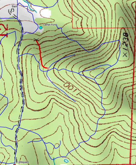
This is a topographic view of a part of “our mountain.” You may recall the panoramic view from the mountain top, which is seen in the upper right part of the map above. In the upper left side of the map, notice the red line I have drawn. This line represents a ravine that cuts it’s way down one part of the slope, where lead ore has been extracted in the past. Today’s post will show what the upper portion of this ravine (and past mining locale) looks like. At the lower part of the red line, you can see the crossed pick-ax symbol that the USGS used to indicate the presence of a mining operation at the time the area was mapped. We will explore the lower portion of the ravine in a future post, when more leaves have fallen and the area becomes more conducive to photography.
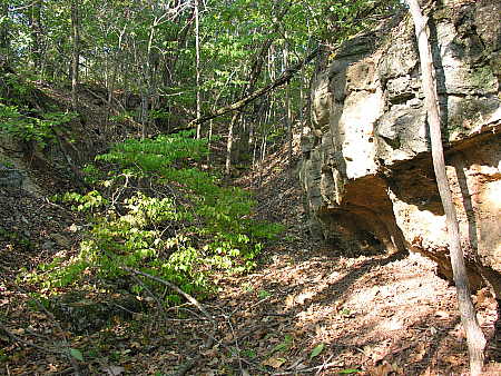
This picture was taken at about the midway point of the mining area, looking up the ravine. Notice the rock outcroppings on the right. This is the result of the ore extraction process that occurred here.
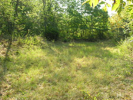
This photograph shows a dry pond site at the top of the ravine, denoted on the topographic map as a red O. It was my initial belief, upon first seeing the dry pond, that it was an unsuccessful stock tank for cattle that at one time grazed a large, crescent-shaped pasture midway up the mountain. I have now come to believe that it was constructed to be a revetment, or containment pond, to prevent a deluge of water from cascading down the ravine during the thunderstorms that sometimes manage to avoid bypassing our property.
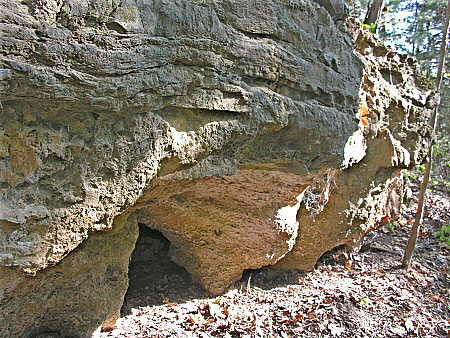
The erosion that has occurred in the exposed rock outcroppings has created small caverns at the base of the rocks. Although there was nothing in this hole at the time of this photograph, I am sure that it has been a shelter for some critters from time to time.
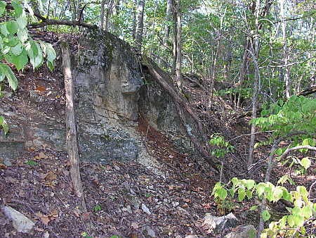
This is another rocky ledge in the upper ravine area that has been created by the mining activities of the past. One day, I would like to accompany someone trained in geology through this area, so that I can learn to understand what I am seeing in these outcroppings more fully.
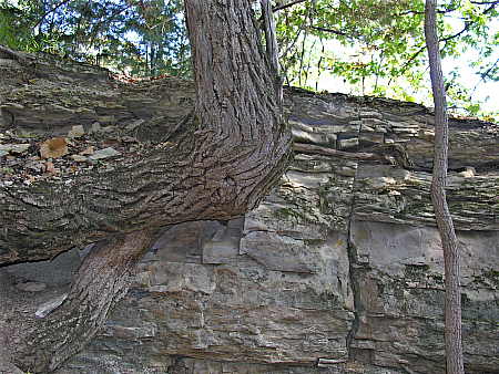
This oak (?) tree appears to be growing directly out of the rock.  I find it interesting to see how it grows horizontally, and then makes an abrupt 90 degree turn, again reaching for the sky.
So now you have seen the upper part of the ravine where lead ore extraction has occurred on this property. This might be the exact spot where I soon discover the “Mother Lode” silver ore vein on our land. If I do, I’ll keep you all posted. And then again, maybe not. But that’s how legends are born.


I assume the blue lines are of your doing as well. I also assume you use some sort of GPS unit since they don’t look just sketched in. What software package to you use to overlay the points onto the topo maps?
I bought a Garmin GPS unit several years ago in a fit of envy and now it collects dust. But were I to live full time in the Ozark Mountains, I would blow the dust off it and use it more often. Up here in the farm fields of Iowa, it is kind of pointless when in places you have to go miles to change 20 feet in elevation.
Ed – For software I am using a product called DeLorme 3D Topo Quads. It has provided me with all of the functionality that I have required to date, however, I would not bestow any awards for elegance on this product. It is somewhat clumsy to use, and many features are not particularly intuitive, so frequent references to the help files are necessary for casual users such as myself. It has accomplished the job for me, though.
I can either store waypoints and/or routes on my Magellan GPS and transfer them onto my computer at a later time, or I can hook my GPS to my laptop and map trails, etc. in real-time. If you are interested, you can see the portable mapping setup that I devised in a previous post that I entitled “If They Can Do It, Then So Can I” which can be found at the following link:
http://www.mitzenmacher.net/blog/?p=126
Using the setup shown in the link above, I created a map of the trail system that you see depicted as blue lines in this post. I created the lines by simply driving over the trails while the computer and GPS were operating.
It is quite simple once you have the devices talking to each other properly, but there is the rub. I would check the technical section of the mapping software publisher’s website to determine whether there are known issues for interfacing you particular Garmin GPS. I believe Garmin units usually require “special handling” as they utilize proprietary communication signals, rather than the standard NEMA communications protocol. When you do get the devices communicating, it is fun to play with.
I may not comment often, but I love to read your blog everyday. I alway seem to learn something. Thanks, Squire
Do you test your wells for lead?
Sam – Thank you for the input that you provide. I appreciate it always.
FC – We do test our well on a regular basis for the following:
E. Coli bacteria
Lead
Atrazine and Simazine (pesticide indicators)
Nitrates
Nitrites
Chlorine and chloroform
Calcium hardness
Magnesium
pH
And thank you for reminding me – I have a test kit sitting on my desk waiting to be utilized.
Pingback: Ranch Ramblins » Blog Archive » Better To Be Safe Than Sorry
Hi,
I just surfed into your fine blog via a search engine from a Boise D’Arc reference. I enjoyed my visit immensely, and will kick through the archives when I have a bit more time.
I was intrigued by your mention of the silver and lead mining. I’m retired, and a recreational prospector for enjoyment. I enjoy the fruits of my Geology courses in college more now than ever before.
This link may interest you, though I don’t know which county you are in. You can use the USGS site to access free digital maps and other resources online that may help answer some of your questions about your local geology.
http://ngmdb.usgs.gov/ngm-bin/ILView.pl?sid=q250_13038_us_c.sid&vtype=b&sfact=1.5
Regards,
faaus
Larry, thanks for the link to the geologic map on the USGS site. The map covers the area we are located in. It looks as if our property is located at the confluence of three different classifications – Oc, Op, and Mb.
Hal –
I enjoy your blogs. We’ve got a place in the Boone/Marion County lead and zinc district, had the severe ice damage same as you, and have a “mountain†that’s 1200+ feet, as well. Have you found any galena or sphalerite crystals around the old dig? Best to look after a rain with the sun shining on wet ground & they’ll sparkle.
I understand that the lead with silver in it is down in the southern part of Arkansas closer to where the hot springs and diamonds are found, but then again, they say none of the old mines in our area went down very deep, so who knows what’s below?
We love everything about the area with the possible exception of the summer ticks and chiggers (sulfur powder on the ankles and pant legs helps), – and OK, temps above 100 aren’t so great, either. But that’s life.
Keep up the great blogs!
Bob
I have enjoyed reading your blog and was interested in seeing if you would allow someone to take some shale samples at the few of the out croppings you have shown in the photos above. The samples would be used for a 7-8 grade science class.
Dan
Dan,
We’re not interested in having any shale sampling performed on our property, thank you.
No problem, figured I would ask. I was looking for some samples with higher levels of uranium. According to the us geological survey your little out cropping has some of the highest levels in the state.
Dan